
MOUNT PINATUBO first entered my life when I was just a kid. It was a lazy Saturday afternoon in June when me and my younger brother, then young and carefree, were holed up in our room busy beating up baddies in our video games. At around 3 PM without warning, the world around us suddenly became dark. It would stay that way until the next morning when me and my family woke up, went out of our home, and saw that our entire surrounding’s now covered in thick layers of strange white substances. I remember being delighted by them for they look like snow, something I’ve only seen in Hollywood Christmas movies but soon enough, glee was replaced by feeling of horror, then anguish as I learned that the powdery white substance covering our backyard are not snow but volcanic ashes from a violent eruption yesterday, and they nearly engulfed our entire home!
So over the next few days, we would busy ourselves cleaning our backyard and house roof of volcanic ashes. Along the line, we would also hear from the TV news affirming that the volcanic eruption we experienced on that fateful Saturday afternoon was disastrous and is one of the most powerful in the 20th Century. There were reports that ashes from the eruption managed to reach the other side of the globe but the most distressing parts are that numerous lives are lost, entire towns near the volcano were wiped out from the face of the Earth, and that the landscape of a large portion of Central Luzon has been changed overnight from fertile agricultural plains to being a barren lahar covered desert thereafter. When those grim news finally sank in to my mind, I finally understood, really understood, just how fortunate my parents, siblings and I were-to be located a hundred kilometres away from Mount Pinatubo.
Nearly thirty years have passed since that fateful Saturday afternoon even as I’m sitting here on a quiet corner of my room doing mandatory confinement in the midst of another disaster-this time a worldwide pandemic. On another lazy afternoon in order to pass time, I decided to browse through some of my old mountaineering photos that has become precious memories of the life I’ve become passionate about for the last five years. Looking at them, I can’t help feeling a sort of glow. They have become my light in this dark and somber times. While rummaging through photos of Mounts Apo, Dulang-Dulang, Pulag, Kitanglad, Halcon, Ulap and many other more, I chanced upon a group of photos taken nearly four years ago that reminded me again of THAT fateful Saturday. This time though, the photos gave me bloom instead of doom and more importantly, a hope for a brighter future. It was the time Mount Pinatubo re-entered my life once again.
DAY ONE

We were trekking in silence for a few hours after not having overcome our sleepiness in the wee hour of the morning en route to Sapang Uwak Village. The background around was still mostly pitch black, I could hardly remember much on the land we were walking except it was mostly rolling and moderately ascending, and that we were led by two kind Aeta guides. At some point, we could not contain our languidness that all the fourteen of us managed to lie comatose on the dirt trail for probably half an hour before the first light of dawn finally appeared, invigorating us and slowly revealing a landscape dotted various bushes of wild sunflowers.


At some point, we reached Sapang Uwak- a mountainside village consisting of houses made of bamboo and cogon grass inhabited by the Aetas-the indigenous people here who were the original inhabitant of the Philippines before later settlers drove them up to the mountains. They were friendly to us and made us feel at home even as we laid down our bags, rested a bit, and ate our breakfast while the sun rose illuminating a panoramic view of the central Luzon landscape below us, with the recognizable silhouette of Mount Arayat from afar being the center of it all.

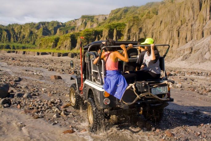
Once we’re done with our breakfast we resumed our hike, mindful that this would be a very long journey to the volcano. For your information, there are three known trails to Mount Pinatubo. Two of them are from the south or the Porac side of the volcano, where the Delta Five and Sapang Uwak trails’ located. The Delta Five trail is the one where you have to do a lot of river tracing and the most technically difficult of them all, while the Sapang Uwak is the longest and the one where we are currently using right now. The third one is located at the north side of the volcano and is otherwise known as the Capaz trail. It is the most famous and touristy of them all. Here, half of the time you’re essentially riding a 4×4 jeep through vast lahar field before trekking for an hour or two to the Crater Lake. For a moment, I kept thinking how cool it would be if we’re also allowed to hike the Delta Five trail for the day, then back trail the following day via Sapang Uwak. But since we weren’t allowed so, we have to make good what is handled to us. And mind you, Sapang Uwak trail is still a very challenging, not to mention, a very long hike topping out at twenty eight kilometres in length one way!
In the next hour we would trek on a second growth forest mostly consisting of banana trees that are probably planted by the Aetas, occasionally bumping into some of them. They are either gatherers or hunters. I even saw an Aeta hoisting a hunting rifle-a proof that they have adapted to the modern times. Before we knew it, the forest would gave way to a vast swath of cogon or “talahib” grassland that are taller than average human beings. Brown soils beneath our feet would also turn into gray sands- a sure sign that we’re getting closer to the volcano itself but is actually still many many kilometres away. The sun is now high above us, mercilessly beating down on us, and with little to no shade to cover us, it felt like trekking on a scorching desert.


Slowly but surely, the volcano became visible to us from a distance. The landscape around us also has changed dramatically, as I can now see various nameless valleys and peaks that were probably remnants of a much bigger volcano in the past before it exploded violently decades ago. There are hardly any trees here as only low lying grasses and some occasional talahibs could grow on the still lahar covered landscape. All in all, the scenery around us, consisting of endless spaces of greenery, is stunning and otherworldly, and being here would make you feel like you’re exploring another planet. It is hard to believe that what was once a scene of death and destruction has become a place of calm, tranquility and of course, of endless beauty.


We would pass to the only water source here on the trail, where we took full advantage of it freshening ourselves up, refilling our water reserves and of course eating our lunch. An hour later we’d hit the trail once more where soon enough, we finally caught a glimpse of Mt. McDo-creatively named after McDonald with “McDo” being the Filipino colloquial term for the iconic American fast-food chain because they say that from afar, the mountain looks like a giant golden arches. Soon hereafter, we would finally reach the top of Mt. McDo where there’s a huge campsite that affords you a panoramic view of the volcano, and here, we’d lay down our heavy backpacks, pitch our tents, and finally took it easy for the rest of the day, mindful that we have to get up early the next morning for the summit assault to the top of Mount Pinatubo.

While waiting for the day to end I would roam around the campsite marveling at the jagged scenery around us fantasizing myself as Frodo that is journeying through Mordor of the Middle-Earth. With the sun setting I took a long look at the volcano thinking it was Mount Doom before clouds finally engulfed the entire scenery, closing the curtains for what would be the first act of our climb.


DAY TWO
It’s 3AM in the morning, the clouds that brought forth rain to us yesterday evening has dispersed, setting the stage for what would be the second and the final act of our climb. The sky is still dark even as we readied our day pack, leaving our tents and heavy belongings here momentarily in the campsite to be looked after by one of our trusty Aeta guide. Looking at the distance, we could see the dark silhouette of the giant volcano we’re about to embark to even as we bowed down our heads and prayed, hoping that Lady Luck would smile on us this fateful day.
A deep valley separates Mt. McDo, where we are currently at right now, and the volcano itself-Mount Pinatubo. Even in the dark, I could see that in order to get to the top of the volcano, we have to plunge deep into an abyss, then climb a steep seventy to eighty degrees trail before reaching the height of the crater rim. With only our headlights as well as our steely resolve to reach the top guiding us, we descended, using extreme caution in near darkness on a very loose trail for an hour, relying on our feet, hands, and occasionally, our butts.

Upon reaching the deepest pit of the valley we would take a short break before immediately starting our final ascent, going through a grassy seventy degree uphill climb that I imagine would be very draining had the sun been high up in the sky. Even then at this early hour in the morning it was already killing our legs but soon enough, the dark sky started painting itself with golden colors and for a short moment I turned around to see how far I’ve come, there it is…the sun rising majestically over a rim of dark mountains.

I rose both my hands while looking at the rising sun, imagining myself as Rocky Balboa victoriously standing on top of a mountain while preparing for his upcoming fight against Ivan Drago. Soon thereafter, my pace have noticeably become faster even as I become more motivated, rising higher and higher until finally, no more solid grounds lay in front for me to lunge upward and that’s when I finally stopped, looked down, only to be greeted by one of the most amazing sight I’ve ever seen in my life.


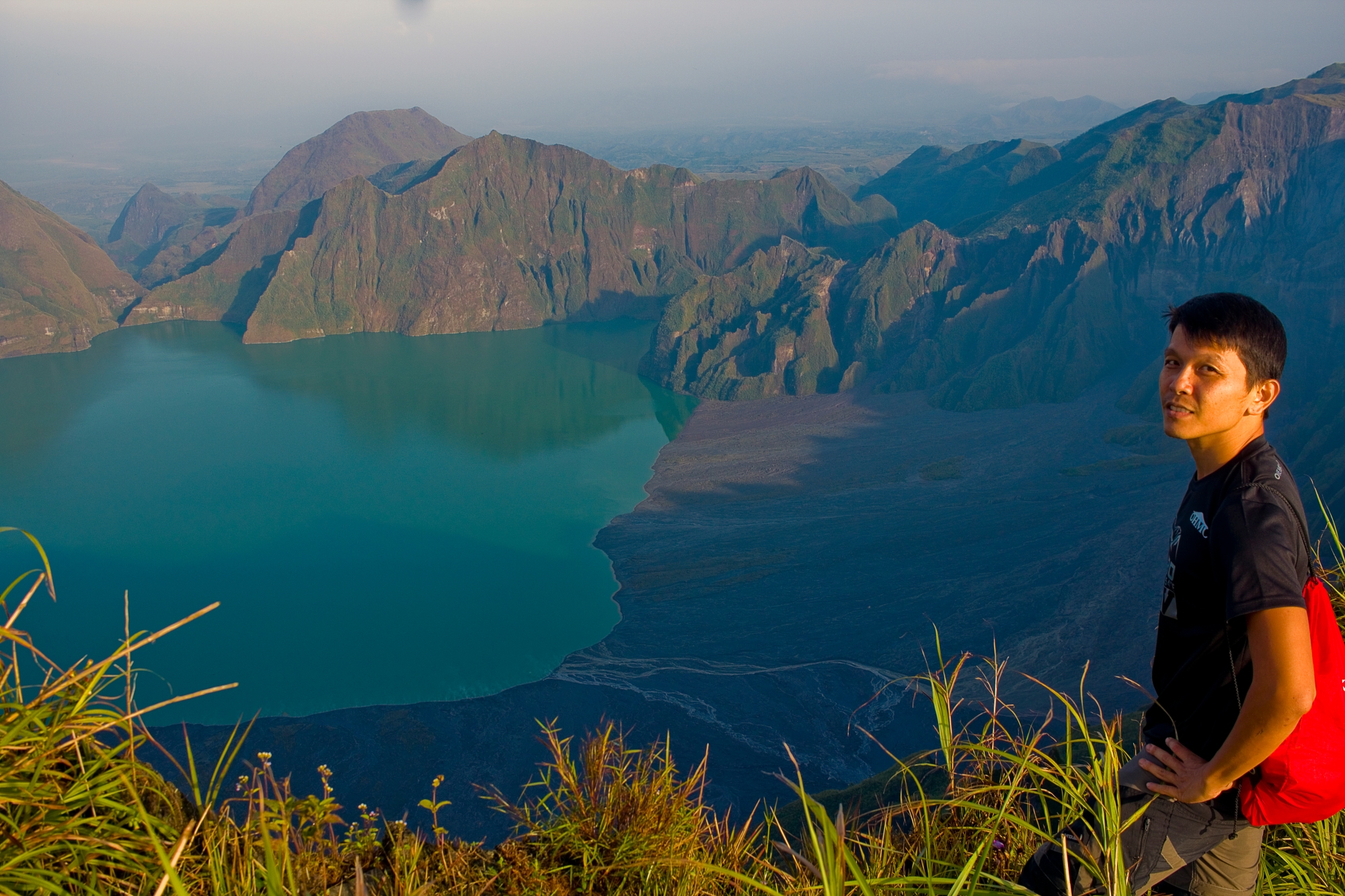
Spanning nearly as wide as my eyes can see is the volcano’s Crater Lake, its turquoise colored waters almost entirely surrounded by cliffs that steeply rises from it. Dramatically beautiful, one could easily imagine that they are looking at a picturesque fjords of Norway rather than a vast caldera. Even though this is not my first time here as I’ve once hiked to the lake itself via the popular Capaz trail, standing here on top looking down gives you altogether a different perspective. From here everything is so calm and serene, a stark contract to what the volcano was decades ago when it was a place of great suffering. Perhaps this is a testament to the healing power of nature. Or it could be an allegory that like a phoenix, beauty will rise from the ashes of destruction.


After staying for nearly an hour gleefully capturing the beauty of the crater and its surrounding area with our smart phones and digital cameras we began to descend just as the clouds started to shroud the area. Another hour later and we’re all at the campsite where we rested a bit, ate our breakfast before finally breaking our camp and starting our hike back to the jump off point. It would be a long trek as expected where morning soon turned to noon, noon becomes early evening but by 7 PM we’re all safely at the jump off point where we’ll freshen up, waited for each other to get ready before turning into our rented van to drive back to Manila.


CONCLUSION
It was a great two day adventure. So great that during that time I momentarily forgot about the volcano’s violent past. Ever since that fateful trip, a lot of things have happened. I would climb many more mountains, some easier, others even more difficult than Pinatubo. As for my life since then, just as it is with hiking, it would go through a lots of ups and downs. For now while I’m writing this blog, I’m at a low point of my life confined in my own home, bored, not being able to do much as the world battles an invisible enemy known as the corona virus. Yet I’ll hold on to my two memories of Pinatubo. First and foremost, I’ll always remember the volcano for her violent past. It serves to me as a reminder of the fragile nature of our existence and how a single moment can change everything you take for granted. Therefore we must always focus on what’s important to us, be grateful and appreciative of what we have, spend more times with our loved ones, and most importantly live our life without regrets for tomorrow is never guaranteed.
I’d also hold on to my second memory of Pinatubo, especially of the moment when I’m standing triumphantly on the top of the volcano only to be floored by her beauty and how she was able to seemingly rise from the ashes of her dark past to becoming an better version of her own self for the world to see. It gave me hope that we’ll one day get through this dark time stronger and wiser than before, and that we would one day beat this pandemic. In the meantime, I’ll do my part by staying home to stop the spread, reflect from my past mistakes, learn some new skills, stay positive, and never stop improving myself for when this dark chapter finally closes, I’ll be ready for the brave new world that lays ahead of me.

